This is the route I plotted out in the Trailrunner software. You can download an image and then set coordinates. Using GoogleEarth I was able to also find rough elevations for the different points. By drawing and connecting the dots, you can make tracks and then combine those to form routes. It gives you a total distance and elevation numbers.

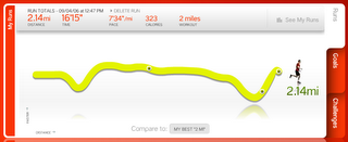
I then ran this 2.02 mile run with my Nike+iPod. This is the readout of that 2.14 mile run from nikeplus.com. So it was pretty accurate - the run and the map were less than 100 meters off over the distance. You can see the dip at the end of my run where I came up the 152 stairs, HOLY SMOKES! I think the dip near the beginning is were I ran down the "X".

No comments:
Post a Comment